This section includes details about all the individually named trails in the vast network of them that blankets the mountains of Western NC. Each trail listing has its own bookmarkable page to make it easy to find later, with all of its stats, photos, and a map (where available).
This is a National Recreation Trail and a Kids In Parks TRACK trail. It was constructed by the Youth Conservation Corps. The trail has several interpretive signs along the way which point out common plants, trees and animals which can be found in the Pisgah Ranger District.
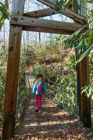
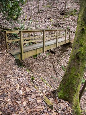
The trail rises on the hillside behind the Ranger Station and Visitor Center. After climbing a few steps, an elevated canopy walkway carries you over a steep hillside at eye-level with the higher tree branches. Then there is a long, neat suspension bridge located about halfway around the loop. The trail drops down into a stream valley and crosses a couple more wood bridges before coming out at the Exercise Trail. You can use the Exercise trail to add some more distance to your hike if desired.
Highly recommended, especially if you have kids!
A trail is different from a hike in that a hike may use more than one trail, only part of a trail, or roads to connect between different trails.
If you just want the details needed to go take a hike, start with our Best Hikes section for full and complete guides that stitch trails together into a great trip, including directions, maps, descriptions, and photos. Although some trails do make great hikes, sticking to a single named trail like you'll find on these pages doesn't always make for the best experience.
The trail listings below are most useful for researching raw information from our database to make up your own day hikes or overnight loops out of the trail network.
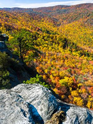
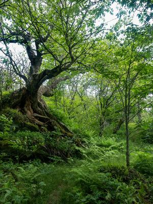
Ascends moderately through mixed hardwoods and then runs slightly downhill along the crest of the ridge on an old logging road. It descends steeply for a brief stretch into the flats right above the cliffs, in an open oak forest. There are a couple of old logging roads that diverge here; keep left at a couple of faint intersections to reach a fantastic viewpoint at the top of the cliffs. Grandfather Mountain looms in the background above Lost Cove. Stay back from the edge and don't trample the moss that grows between the rocks.
To find trails by location, visit the Trailheads section of the site. Each Trailhead has a listing of all the trails (and hikes!) in the network near that location.
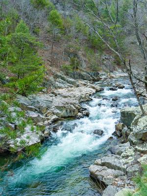
This trail follows Big Laurel Creek through a scenic gorge to its junction with the French Broad river at the old logging ghost town of Runion. This trail is especially nice in early spring when there are many wildflowers blooming along the path and riverbanks, and when the water levels are low and the creek runs clear. The creek is quite large by the time it enters the gorge - almost a river, perhaps explaining the trail's confusing name - and its popularity with boaters and fishermen.
The trail is an old railroad bed which used to carry logs to the Runion sawmill in the 1920's, and as such, is mostly level. However, it's rocky and rooty in spots, so do bring the boots.
A few small streams flow across the trail at various points, and bluffs tower over the river making the valley narrow and enclosed with precipitous slopes on either side. Huge boulders choke the gorge forming raging rapids in places, and a few deep holes invite strong swimmers to take the plunge in warm weather. The trail nears its end at the former logging town of Runion. In its heyday, Runion was home to more than 1,000 people. Brick chimneys and crumbling foundations still remain - one of the few "ghost towns" in North Carolina.
The trail crosses the railroad at the confluence of the Big Laurel and French Broad, and ends on the other side of the tracks at a tranquil riverside flat. Trespassing on railroad property is dangerous, so just follow the trail straight across (after looking and listening for trains - this is an active line!) and do not attempt to cross Big Laurel Creek on the railroad bridge like some have in the past.
Trails are listed by their official name given by the managing land agency. We list, where available, the steepness, tread condition, and overall difficulty of the trail, as well as its length and overall elevation change.
Length
Trail length is one-way. If you are hiking a single trail out-and-back, then double the length. While some guides show the round-trip length by default, many people's hikes combine trails or use only portions of trails, so the most accurate thing for us to do is just list a trail's actual length.
Difficulty Ratings
The US Forest Service, among others, separates trails into just three difficulty levels. We think that's a bit condensed given the variety of trails we have in our region. Even ski slopes usually have at least 4 difficulty ratings!
So, we have devised four difficulty levels for all of the trail and hike listings on this site. Here's a description of typical conditions you might find on hikes with a given difficulty level.
This neat little loop starts and ends in the Davidson River campground, making it a must-hike if you're staying there. Described counterclockwise, but can be hiked in either direction.
Starting at the campground's amphitheater, the trail climbs an out-and-back portion to a split; turn right. The trail circumnavigates the campground near the bottom of the ridge, then joins with the Seely Memorial Trail. It reaches a junction with the Exercise trail; turn left to begin following the Davidson River upstream.
The trail then pulls away from the river, steepens, goes 'round a ridge, and follows smaller stream up through a shallow cove.
At the junction with North Slope Connector, turn left to stay on North Slope. The trail levels out and starts traversing North Slope Ridge in a sidehill fashion. It dips into small coves goes out around little ridges. There is one interesting bridge over a deep gully, and there are a couple of smaller log bridges.
The forest is mostly mixed hardwoods; Hemlock groves in this area are mostly dead due to Hemlock Woolly Adelged infestation. There are some neat mountain laurel and rhododendron tunnels.
The trail then descends moderately again to the amphitheater and campground.
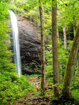
From FS 74, the trail begins as an easy, 0.5 mile route to its spectacular eponymous waterfall - a great family hike. There are a few tricky sections (including one where a fallen tree has exposed some slick bedrock), but overall the route is in fairly good shape. The trail passes through a virgin forest, including a former hemlock grove containing (formerly) very large trees, before coming out on the stream below the falls. It's possible to cross the stream and walk into the grotto behind the falls for a neat view out into the forest. This is the [Douglas Falls - Lower Approach Hike](/besthikes/big-ivy-coleman-boundary/lower-douglas-falls).
Most people stop at the falls, but if you're continuing up to the Mountains to Sea Trail, look for where the trail veers left up a set of rock steps just before reaching the falls. From there, it meanders uphill to a large boulder sitting below the cliff band, overlooking the falls. It then continues uphill along the cliff band, wraps around the end of that, and continues its climb in the stream valley above the falls. The trail passes through the Craggy Wilderness Study Area and the environment from here up to the Mountains to Sea Trail is remote and pristine, though the trail is blazed.
You'll wrap into the next cove south and pass The Cascades, another high waterfall that's difficult to see in the summer and during low water flow. The trail moves into rich, old-growth northern hardwood forests blanketed in mosses and ferns as it climbs including some enormous old hemlocks (which, sadly, are all now dead). The trail climbs through a series of switchbacks as it nears the terminus at the Mountains to Sea Trail.
Turning right (south) on the Mountains to Sea Trail leads to the Parkway and the Craggy Gardens Visitor Center. Those wishing to access to the falls on a much more difficult, rugged, and steep hike than from the lower parking area can start at the visitor center, hike down to the falls, and back out again for a round-trip of about 7 miles. This is the [Douglas Falls - Upper Approach Hike](https://www.hikewnc.info/besthikes/craggy-gardens/upper-douglas-falls).
This trail was rebuilt in the spring of 2014 by Elevated Trail Design. Climbs past an open meadow through some switchbacks before winding around atop Hickory Mountain a bit, and crossing the summit in a nondescript forest setting. There are a couple of rocky spots and a wet dip or two, but it's pretty smooth overall. Limited wintertime views to the north. There is a good photo gallery of the trail & construction on [the trailbuilder's portfolio page](http://www.elevatedtraildesign.com/portfolio/dupont-state-recreational-forest/).
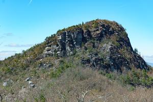
Rocky climb along the side of the eponymous mountain to its summit. Passes by a lot of neat rock features. There are fantastic views from the summit. Very popular; makes up the Table Rock Best Hike. Passes through varying forests and open areas cleared by wildfire in the not-to-distant past. Shares the first half of the path with the Mountains to Sea Trail. The upper half is unblazed and a few side-paths take off in all directions, but overall it is fairly easy to follow if you keep on the most well-worn tread.
**Pisgah Inn to Black Mountain Campground**
Pisgah Inn, BRP mp 408.6 to Folk Art Center, BRP mp 382: from the Pisgah Inn to the Mount Pisgah Parking Area, the trail is co-signed as the Buck Spring trail. This leads past the old Buck Spring Lodge built by George Vanderbilt, where there are interpretive signs. From the parking area, the trail joins with the Mount Pisgah trail which leads to the top of Mount Pisgah itself. Continuing toward Asheville, the trail is co-signed as the Shut-in Trail and follows parts of Vanderbilt's original route to the Lodge from his Estate. Follows the Parkway closely along this section and meets up with it several times. Good day-hikes can be made from these sections of trail. Joins with trails leading to the Mills River and Bent Creek areas of Pisgah National Forest.
The trail then crosses the French Broad River, Interstate 26, US highways 25, 74-A, and 74 on bridges with the Blue Ridge Parkway as it skirts the Asheville area on a relatively low elevation and low relief stretch. At the Folk Art Center, the trail begins climbing again toward Mount Mitchell.
From the Folk Art Center, BRP mp 382 to Balsam Gap at BRP mp 359.8. Follows the Blue Ridge Parkway closely most of this segment. Travels from the low-elevation area near Asheville on a mostly gentle climb to Bull Gap near Ox Creek Road. Follows a historic carriage trail through many switchbacks to [Rattlesnake Lodge, one of the best hikes in the region](http://hikewnc.info/trailheads/mst/guidedhikes/rattlesnake.html). Ascends more steeply to Lane Pinnacle, where there are great views, then undulates over to the picnic area at Craggy Gardens, a high elevation area. A popular, heavily traveled section of trail goes from the picnic area to near the Craggy Visitor Center. Passes through the gardens and a historic trail shelter on this stretch and is also known as the Craggy Gardens trail.
The MST splits left, downhill, and goes to the junction w/ Douglas Falls trail. The trail then Climbs back to the Parkway and follows it closely, up and down, to Balsam Gap. There are some spectacular views on this part of the ridge, of the Black and Craggy Mountains, the Asheville watershed, and northern Buncombe County.
From Balsam Gap, BRP mp 359.8 to the Black Mountain Recreation Area by the South Toe River: climbs Blackstock Knob in a spruce-fir forest above Asheville Watershed. Follows knife-like ridge, then descends on an amazingly well-built section of trail to fields below Potato Knob. Fantastic veiws of Asheville reservoir. Descends to Mount Mitchell Road, NC 128. The segment from NC 128 up to [Potato Knob Fields](http://hikewnc.info/trailheads/mst/guidedhikes/potatoknob.html) is one of the best hikes in the region.
Past NC 128, the trail climbs gently, co-signed with the Buncombe Horse Range trail (on an old railroad bed) thru high-elevation hardwood forest to point near Camp Alice at Mount Mitchell State Park. Here it turns left; ascends very steeply on a segment co-signed with the Camp Alice trail to [Mount Mitchell's summit](http://www.hikewnc.info/gallery/mount-mitchell-state-park-hiking/), the highest point east of the Mississippi River at 6,684'. The trail then descends 3600' in 5.5 miles to the Black Mountain Campground via the Mount Mitchell trail where there are old-growth spruce forests. This last segment, from the summit to the campground, is the [Mount Mitchell hike](http://hikewnc.info/trailheads/mitchell/guidedhikes/mountmitchell.html) on this site.
Gentle climbs and descents with a relatively smooth surface, sometimes on pavement or other trail structures. No tricky water crossings or exposed cliffs. Some trails may be wheelchair and stroller accessible. Family-friendly meaning almost anyone including smaller children should be able to complete these.
Moderate
Some climbs and descents with a few obstacles on the trail surface. May contain water crossing that are not overly difficult and occasional exposure to drop-offs beside the trail that aren't too risky. Most people with some experience hiking, including older children, should be able to complete these.
More Difficult
Significant climbs and descents with considerable elevation change, but short of the hardest trails in the region. A trail surface that can be somewhat rough in places, but short of dangerous climbing or rock scrambling. May contain tricky water crossings and some exposure to cliffs and drop-offs beside the trail. Experienced hikers in good shape should be able to complete these.
Most Difficult
Large climbs and descents with high elevation change. A trail surface that can be very rough in places, including possibly dangerous exposure to cliffs and drop-offs, and rock scrambling. May contain very tricky water crossings. Only experienced hikers in excellent shape should attempt to complete these, which are among the most difficult in the region.
Steepness
The Steepness rating factors in the way in which a trail's elevation is achieved. This does not take in to effect the overall elevation change on the trail (which is listed separately). Very short sections of the trail that are out-of-character for the rest don't affect this rating, but will be mentioned in the description.
Level
No appreciable elevation change along the length of the trail. The trail may not be completely flat, but it is atypically so for the mountain region.
Climbs Gently
Gentle climb, can be done at a normal hiking pace, ending at a higher or lower elevation from one end to the other. No sections are considered steep.
Climbs Moderately
Moderate climb, which may slow a normal hiking pace slightly, ending at a higher or lower elevation from one end to the other. Some sections may be moderately steep, but the trail is not extremely so overall.
Climbs Steeply
Steep climb, which considerably slows a normal hiking pace, ending at a higher or lower elevation from one end to the other. Some sections may be extremely steep, and the trail may be very steep overall.
Few Hills
Gentle to moderate climbs both up and down, but with both ends at roughtly the same elevation. The hills may slightly slow a hiking pace.
Hilly
Moderate to steep climbs both up and down, but with both ends at roughtly the same elevation. The hills will considerably slow a hiking pace.
Tread Condition
This characterizes the average condition of the worst parts of the trail surface. Very short sections of trail that are out of character for the rest don't change this rating, but will be mentioned in the description.
Paved
A smooth, paved surface. Pavement may be broken or raised in areas, but is generally smooth.
Graveled
A fairly smooth, improved surface consisting mostly of bonded gravel, small stones and/or sand.
Few Obstacles
A natural surface with only occasional small obstacles such as roots, rocks, ruts, or eroded or muddy areas, that won't substantially slow a normal hiking pace.
Some Obstacles
A natural surface with sustained small or occasional medium-sized obstacles such as rocks, roots, ruts, or eroded or muddy areas that may slightly slow a normal hiking pace.
Moderately Rough
A natural surface with sustained medium-sized or occasional large obstacles such as roots, rocks, boulders, deep ruts, wet water crosssings, or significant muddy areas, that will substatially slow a normal hiking pace.
Very Rough
A natural surface with sustained large obstacles which may require tricky footing over deeply eroded gullies, hand-over-hand maneuvering, long stretches of large and exposed gnarly roots, or extremely deep water crosssings and/or muddy areas that will make travel difficult and severely inhibit a normal hiking pace.
These descriptors include typical conditions which may vary with weather, erosion, trail maintenance, and season. They may overlap within the difficulty levels somewhat. Determinations are subjective.
Why No Time Estimates?
We don't provide time estimates for trails like some guides do, because that is entirely dependent on how quickly you hike. Some folks like to move along at a consistently fast clip, while others like to stop frequently, take photos, eat snacks, and soak up the views. If you're not sure how fast you hike, pick some shorter trails to start and time yourself (or use your favorite GPS app) to get a sense of your average speed, and then use that when estimating how fast you can handle other trails based on their length, steepness, and condition.
I can easily spend all day on a 2 mile trail if the conditions for photography are right!