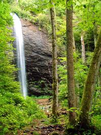
Douglas Falls
At A Glance
TODO: #32 Boilerplate


2.7 mi one-way
Difficulty Rating: 5.48 ![]()
Steepness: Climbs Steeply ![]()
Tread Condition: Moderately Rough ![]()
Lowest Elevation: 4190 ft
Highest Elevation: 5300 ft
Climb Total: 1290 ft
Blaze Color: White
USGS Map Number: 162
From FS 74, the trail begins as an easy, 0.5 mile route to its spectacular eponymous waterfall - a great family hike. There are a few tricky sections (including one where a fallen tree has exposed some slick bedrock), but overall the route is in fairly good shape. The trail passes through a virgin forest, including a former hemlock grove containing (formerly) very large trees, before coming out on the stream below the falls. It's possible to cross the stream and walk into the grotto behind the falls for a neat view out into the forest. This is the Douglas Falls - Lower Approach Hike.
Most people stop at the falls, but if you're continuing up to the Mountains to Sea Trail, look for where the trail veers left up a set of rock steps just before reaching the falls. From there, it meanders uphill to a large boulder sitting below the cliff band, overlooking the falls. It then continues uphill along the cliff band, wraps around the end of that, and continues its climb in the stream valley above the falls. The trail passes through the Craggy Wilderness Study Area and the environment from here up to the Mountains to Sea Trail is remote and pristine, though the trail is blazed.
You'll wrap into the next cove south and pass The Cascades, another high waterfall that's difficult to see in the summer and during low water flow. The trail moves into rich, old-growth northern hardwood forests blanketed in mosses and ferns as it climbs including some enormous old hemlocks (which, sadly, are all now dead). The trail climbs through a series of switchbacks as it nears the terminus at the Mountains to Sea Trail.
Turning right (south) on the Mountains to Sea Trail leads to the Parkway and the Craggy Gardens Visitor Center. Those wishing to access to the falls on a much more difficult, rugged, and steep hike than from the lower parking area can start at the visitor center, hike down to the falls, and back out again for a round-trip of about 7 miles. This is the Douglas Falls - Upper Approach Hike.

This site is part of the
WNCOutdoors.info network
Western North Carolina
Hiking | Mountain Biking | Waterfalls
Advertising Information | Contact Us
©1996-2025 CC-BY-SA | Privacy Policy