From the backpack parking area, the trail reaches Window's Creek a few yards a few yards upstream of Widow's Creek Falls, one of the prettiest in the park. (To reach the falls, take the trail at the parking spot just northeast of this trailhead). It then continues for 2.5 miles along the creek to the backcountry sites and stops. All backpackers must register and pay at the backpack parking area before camping overnight.
This trail is accessible via the Stone Mountain Loop Trail or the Cedar Rock Trail and provides
views of the Blue Ridge Mountain escarpment. The ridges dividing three watersheds (Garden Creek, Widow's Creek and Bullhead Creek) can also be seen from atop Wolf Rock. Signs of old field succession are evident along the trail as it leads through predominantly pine, then mixed pine-hardwood and finally mature hardwood.
Accessible from both Stone Mountain Loop and Wolf Rock trails, this trail leads to Cedar Rock, a large granite outcrop with views to the south/southeast and an excellent view of Stone Mountain.
Accessible from Stone Mountain Loop Trail, this trail leads hikers a half mile along
Big Sandy Creek to Middle Falls and then extends to Lower Falls. The trail dead-ends at Lower Falls.
Starting at the Upper Trailhead parking lot, directly across from the campground road, this trail takes you across the summit of Stone Mountain and down again, past the park's Hutchinson Homestead, and then to 200-foot Stone Mountain Falls. Hikers can also choose to use this trail to access the waterfall or the summit without having to do the entire loop. This trail can also be accessed from the Lower Trailhead parking lot or the picnic area via the connector trail.
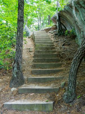
The trail is long and varied, with surfaces including gravel, dirt, wooden steps, and solid rock. It's not very wet, although some parts along the creeks can be. It follows old roads in places and in others it's purpose-built trail. Ratings include the "worst" part of the trail, which is on the northwest side of Stone Mountain; all of the rest of it (including the shortest routes to the summit, the homestead, and the falls) would only be considered Moderate with Some Obstacles.