River Loop
At A Glance
TODO: #32 Boilerplate


3.1 mi one-way
Difficulty Rating: 3.1 ![]()
Steepness: Few Hills ![]()
Tread Condition: Some Obstacles ![]()
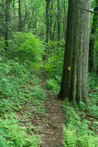
Blaze Color: Yellow
USGS Map Number: 200
River Loop trail is a double-lollipop shaped trail with two loops on each end: the north and south. The Black Mountain Campground sits near the middle.
Southern (Upstream) Loop
The southern, or "upstream" loop, located southwest of the Black Mountain Campground, is described here starting at the hiker parking area at Black Mountain Campground on S. Toe River Road and looping clockwise.
The trail ascends behind the sign boards on a path shared with the Green Knob and Mountains to Sea Trail through a former hemlock grove at the north end of Cove Ridge. In this cove, and along the rest of this loop, most of the hemlocks have been killed by the Hemlock Woolly Adelgid. There are only a few hemlocks surviving here, but they're medium-sized so if they continue to thrive they'll be beautiful in a few years once the Adelgid damage falls away. Otherwise, the cove is beautiful and filled with small trees (many of them birches) and ferns.
The trail bends east to a junction at a rocky spot. The Mountains to Sea Trail continues straight, while the River Loop and Green Knob switch back to the right on a side-hill course now heading west. In a few yards, the Green Knob trail splits to the left leaving the path occupied by only the River Loop trail as it moves through a wet area and toward the nose of a ridge. There are some enormous trees growing here; one notable oak in particular is located right next to the trail.
The trail rounds the ridge and turns to a southwesterly direction on the east side of the river as it passes through more lush forest scenes. It rises slightly to a partial view (better in winter) of the Black Mountains range and Mt. Mitchell to the west. You can get a sense of how high the ridge towers over the river valley from this vantage point, even if you can't see the summit itself.
The trail picks up old logging roads in places, where it gets wider, as it undulates up and down some. The trail swings back to the north around a wildlife clearing with some more partial views before a last leg on an old logging road where it makes a sharp turn to meet up with S. Toe River Road. Turn left and cross the river on the concrete bridge.
The trail leaves the road to the right on the other side of the bridge and picks up another series of old logging roads as it heads back toward the campground on the west side of the river, heading northeast. You'll cross a tributary, Camp Creek, on stepping stones and a smaller tributary draining Higgins Bald beyond that. The trail rises above the river some in places and is generally lush and pleasant. At the bottom of Flynn Ridge, you'll make a short descent to the riverside and arrive back at Briar Bottom Group Campground.
Continue straight on the Briar Bottom trail through the campgrounds, past the Setrock Creek Falls and Mount Mitchell trail junctions, to the main Black Mountain Campground Road. The parking area is just ahead at the campground entrance, to the right and across the bridge.
The Middle Portion
The trail follows the campground roads from the campground's entrance bridge over to the amphitheater. Then the trail turns right, and turns right again at the junction with Devil's Den Nature Trail. It follows the S. Toe River downhill a short distance, climbing up and over some rocks in spots, then follows and crosses a tiny tributary before meeting the northern loop at the upstream bridge over the S. Toe River.
Northern (Downstream) Loop
The northern, or "downstream" loop, located northeast of the Black Mountain Campground, is described here starting at the upstream bridge when coming from the campground via the middle section described above.
Cross the S. Toe River at a killer swimming hole on the sturdy bridge, continuing onto a graveled portion of path. You'll reach a junction - straight ahead is the S. Toe River Road at the Fishing Access parking area (another good spot to park to hike this trail). Left is yellow-blazed River Loop, which winds through the bottomlands along the S. Toe River. There are some massive trees in this stretch of the forest dominated by tuliptree, sycamore, and (formerly) hemlock - though few impressive hemlock do still survive! (These have likely been treated with insecticide to keep Hemlock Woolly Adelgid at bay). The trail meets up with S. Toe River road briefly beside some picnic tables (another potential parking spot) and follows the road a bit under the power lines.
The trail angles left back into the woods, crosses a normally-dry braided stream of the river, and then crosses the river proper on another sturdy bridge, where there are some nice views both upstream and downstream. It turns sharply left, heading back upstream.
The trail climbs the riverbank a bit, affording a nice view down to the river and up to the Blue Ridge on the other side. It descends back into the bottomlands before winding its way back up to the upstream bridge.

This site is part of the
WNCOutdoors.info network
Western North Carolina
Hiking | Mountain Biking | Waterfalls
Advertising Information | Contact Us
©1996-2025 CC-BY-SA | Privacy Policy