Table Rock
At A Glance
TODO: #32 Boilerplate

2.0 mi round-trip
Difficulty Rating: 3.51 ![]()
Climb: Climbs Moderately ![]()
Tread Condition: Moderately Rough ![]()
Highest Elevation: 3940 ft
Climb Total: 660 ft
Configuration: Out-and-back
Starting Point: Parking area at the end of Table Rock Road
Trails Used: TODO dynamic list Table Rock Summit

Begin the hike at the north end of the parking lot (the side away from the toilets). The trail begins to the right of the sign board. The ridge of Table Rock looms high above the parking area right from the start. The trail starts out level, but very quickly begins its steep, mostly relentless climb to the top. You'll pass through a vast spread of Mayapple, particularly noticeable in the spring months.
Not only is it somewhat steep, but the trail quickly becomes very rocky. There is nothing particularly egregious, but some stretches have large stepping stones that have become dislodged and loose due to heavy hiker traffic. Some stretches of the trail sport smooth, sloping rock, so watch your footing to avoid a slip.
The beginning of the trail is in a forest of medium-height hardwood trees; mostly oaks. A few hemlocks and white pines grow in the understory, hoping to overtake the hardwoods and poke out into the sun some decades into the future.
But the forest quickly changes, and the trail becomes more open and sunny. In years past, this area was a forest, composed primarily of a species scraggly tree called Table Mountain Pine. But many of those have died as a result of an infestation of the native Southern Pine Beetle. Only the gnarled trunks now remain. Luckily, this insect has evolved along with the pines, so the trees aren't all killed by an infestation. Sparse sections of healthy pine forest can still be found.
This forest has also been affected by fire. In fact, these pines need fires periodically to open their cones and regenerate from seed. Along the way, you'll see signs explaining fire ecology which mention this fact. Aside from the pines, trailside vegetation consists mostly of rhododendron and mountain laurel. They are prolific, and bloom relatively early here (late May), which is an excellent time to hike this trail.
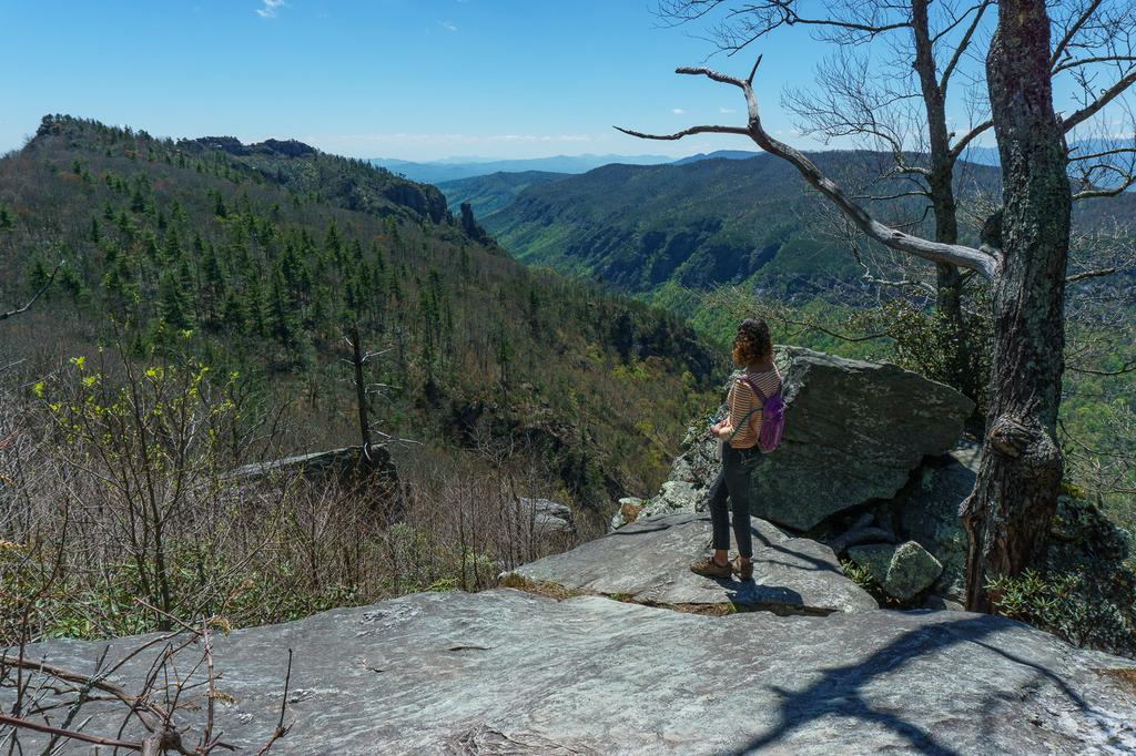
To your left, a nice view opens up through the sparse trees of the Linville Gorge and - to the far left - the Chimneys. These rock formations are some of the closest features we have in the Appalachians to "hoodoos" so common out west - pillars of rock standing apart from a main cliff face, formed by erosion. They are a popular rock climbing destination (as is Table Rock itself) and even have a connection to the famous Linville Falls some miles up the Linville River from this location.
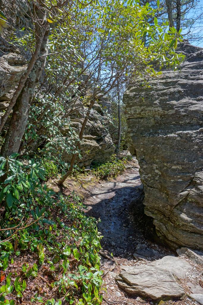
Linville Gorge was formed as the Linville River cut down through a hard, resistant layer of rock into the softer rocks below. Where the river flows over this layer near the top of the gorge, it forms Linville Falls. The Chimneys, Table Rock, Hawksbill Mountain (which you will see once you reach the top), and all the high cliffs near the rim of the Gorge are all formed as a result of that same ancient, erosion-resistant layer of rock. At one point, the trail passes through a neat slot formed by a large boulder that has split away from the main rock face.
As you ascend, and once you reach the top, keep your eyes peeled for the elusive Peregrine Falcon. These graceful, large raptors are native to the area. They are, in fact, widespread across much of the world. But they were eliminated regionally during the 20th century due to the effects of DDT. Since then, they've been reintroduced to the area successfully and are still protected. Rock climbing routes near their high, windy cliff-side nesting sites are closed periodically to ensure that the birds are able to hatch and raise their offspring in peace. The Peregrine's most well-known feature is their hunting style: taking other birds in mid-flight, they dive from high above, striking their prey at literally breakneck speeds.

The trail will go around a ridge and curve to the right. An intersection with a faint path - the old Little Table Rock trail - is at the top of the ridge; bear right, uphill. You will immediately pass onto the cooler, wetter side of the mountain. Here, Carolina Hemlocks grow among the pines and hardwoods with a few Eastern hemlocks as well.
Both hemlock species are being ravaged by the Hemlock Wooly Adelgid, a non-native pest that has a lot less mercy on its host than the pine beetles have. These on Table Rock are still hanging on as of 2021 and some of them look perfectly healthy and unaffected by adelgid. They may have been treated chemically with insecticides to prevent the Adelgids from taking hold.
There is another intersection on the left; this time, with the Mountains to Sea Trail. Bear right, uphill. The rest of the trail is unblazed.
The trail switches back again, climbing in earnest, and goes back onto the open, sunny south side of the mountain. There are some side-paths going in all directions, but just follow the most well-worn path to stay on the main trail. Several rock formations stand out along this section of trail.
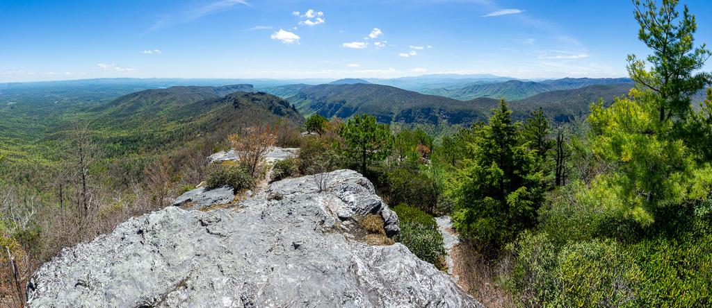
As you approach the top, the vegetation gets reduced down to very short, gnarled growth. It's mostly shrubs with a few stunted trees. But that means the views begin to really open up! The trail officially ends on a small flat area where an observation tower once stood. Despite the tower's absence, views are to be had in every direction, and they are spectacular.
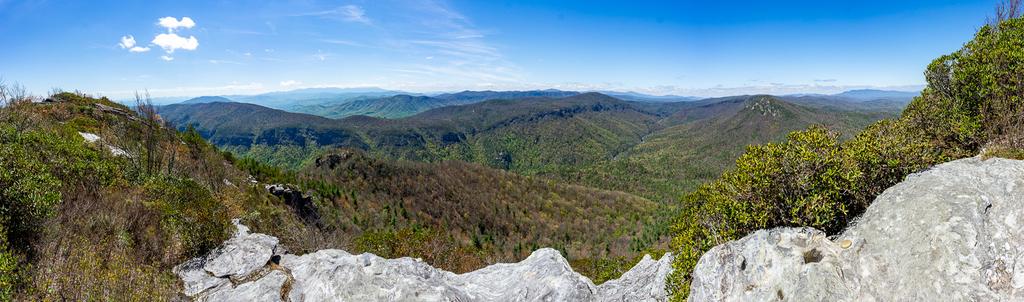
You can travel along the ridge to the south if you're willing to scramble and climb over some very rough rocks. Keep in mind that there are sheer cliffs in almost all directions from the top and stay well back away from the edges. Also, obey any signs posted regarding closures for the Peregrine Falcons during the spring nesting season.
Once you are finished soaking up the views, return to your vehicle on the same path.
Extended Hike Option (+2 mi, minimal elevation change): If you've still got some time and energy to extend your hike, continue straight across the parking lot onto the Mountains to Sea trail and continue through the Table Rock Picnic Area. It's about a mile out to the Chimneys area of Linville Gorge, a rugged section of the ridge offering up more absolutely spectacular rock formations and views like those on Table Rock.


This site is part of the
WNCOutdoors.info network
Western North Carolina
Hiking | Mountain Biking | Waterfalls
Advertising Information | Contact Us
©1996-2025 CC-BY-SA | Privacy Policy