Shortoff Mountain
At A Glance
TODO: #32 Boilerplate

5.1 mi round-trip
Difficulty Rating: 8.07 ![]()
Climb: Climbs Moderately ![]()
Tread Condition: Moderately Rough ![]()
Highest Elevation: 2975 ft
Climb Total: 1200 ft
Configuration: Out-and-back
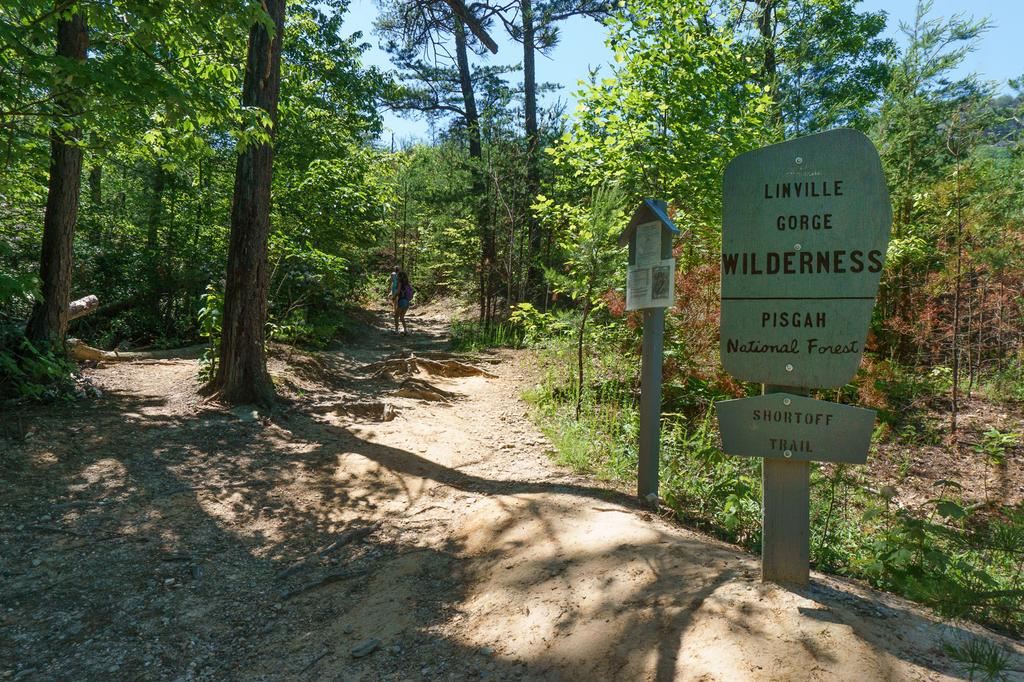
Starting Point: Wolf Pit Trailhead at the southeast end of Linville Gorge
Begin the hike at the back of the parking lot behind the trail sign. The trail starts uphill immediately. And it continues that way all the way to the top. It's never a steep climb, but it never lets up, either. On a positive note, you never lose elevation that you have to make back up again on the way down, and the climb is followed by a very pleasant level walk on top of the ridge. But the first half of the hike is, truly, all uphill.
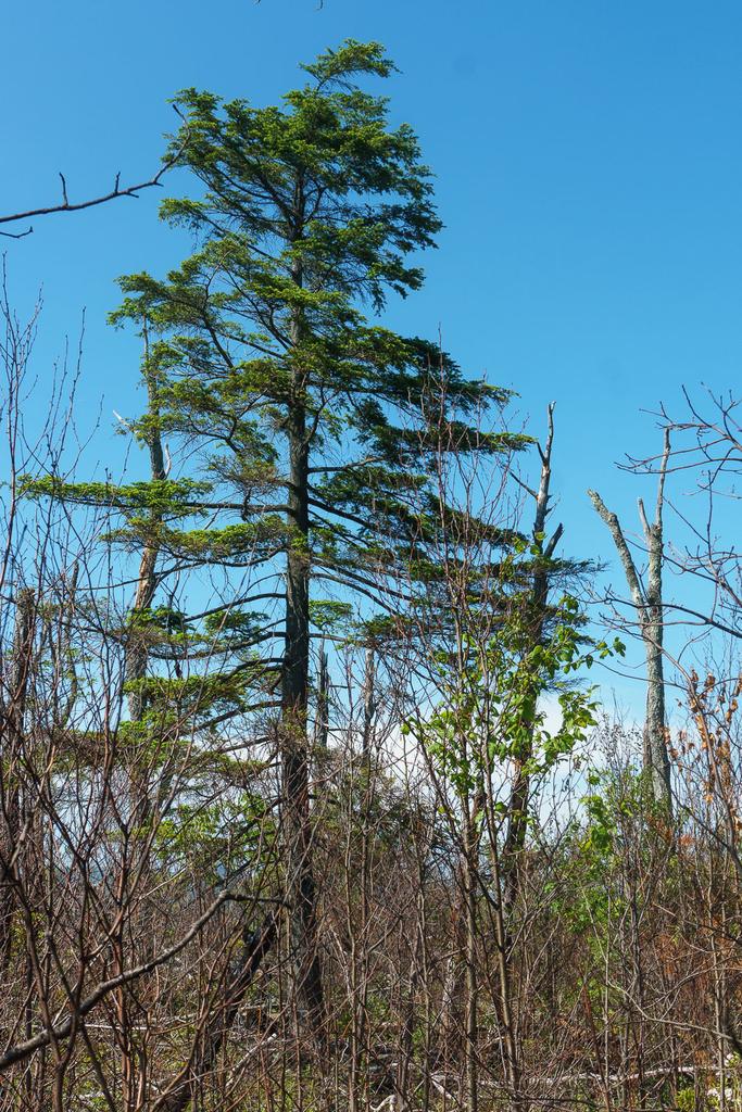
There's forest at the beginning of the hike, but its tenuous grasp on the landscape gives way quickly to brush and small trees, many of them dead, in the fire-scalded area to the right (uphill side) of the trail. Areas along this hike have burned several times over the last couple of decades, most recently in 2017. You'll see many stages of how a forest recovers after wildfire on this route.
The trail follows an old road at first. Less than 0.2 mi from the parking area, the trail veers right, uphill, onto an old jeep path ascending the ridge. A lesser-used trail continues straight ahead, and the junction has signs, unlike many such junctions in wilderness areas. Though the entire hike technically passes through designated wilderness, you should have little trouble staying on track.
Shortcode: Gallery Here
The trail ascends a low ridge coming off the toe of Shortoff Mountain. Since there are few trees, you'll start to get views toward Lake James and the Piedmont region almost immediately. And just as impressive are the views up Shortoff's rocky slopes far above. Look for lush ferns growing beneath stands of shortleaf and Table Mountain pine trees, which may eventually grow over the trail to conceal the views in the coming years. Mountain laurel and rhododendron, which refuse to disappear from the landscape and grow back quickly even when scorched by fire, bloom profusely along the trail in late Spring.
The trail reaches a point where the small ridge melds into the side of Shortoff Mountain, and it angles left into a cove. A few taller surviving trees tower over a prominent boulder in this little sheltered area where a semblance of the Southern Appalachian forests that once covered this mountain has partly survived. But it's a short departure from the shrubby norm as you wind your way back onto Shortoff's main slope.
You'll begin ascending a series of 4 switchbacks on the steepest part of the mountain. A seasonal stream may be heard off to the left, and the trail can be a little wet in places. There are cliffs at roughly this elevation both east and west of here, but this aspect of the slope is gentle enough that the trail was able to be routed back and forth in the soil. The unusual fire-impacted landscape of lush young growth with open areas, dead snags, the occasional taller living tree, and near continuous views makes it easy to forget the climb and really enjoy this part of the hike.
Shortcode: Gallery Here
After the 4th switchback (left), you'll be heading in a generally westerly direction but the trail will swing back gradually north as you approach the summit. The slope is not as steep here. About 0.2 mi beyond the last switchback, you'll reach a junction with the Mountains to Sea Trail, which goes straight ahead (uphill) and left (downhill). (To the right is an abandoned, overgrown old jeep road leading to the summit). Continue straight ahead; you are now following the Mountains to Sea Trail. It's about 1/2 mi to the summit plateau from here.
A series of rock steps near some neat layered outcrops signal that you're nearing the elevation of the summit plateau. Before you reach it, though, a short side path to the left leads to a cliff-top view into the lower end of Linville Gorge with a peak named Pinnacle being the triangular opposing summit on the ridge across the river, with the higher Blue Ridge and distant Black Mountains looming farther behind. Use caution at the overlook - there's plenty of room to enjoy the view, so don't go near the edge.
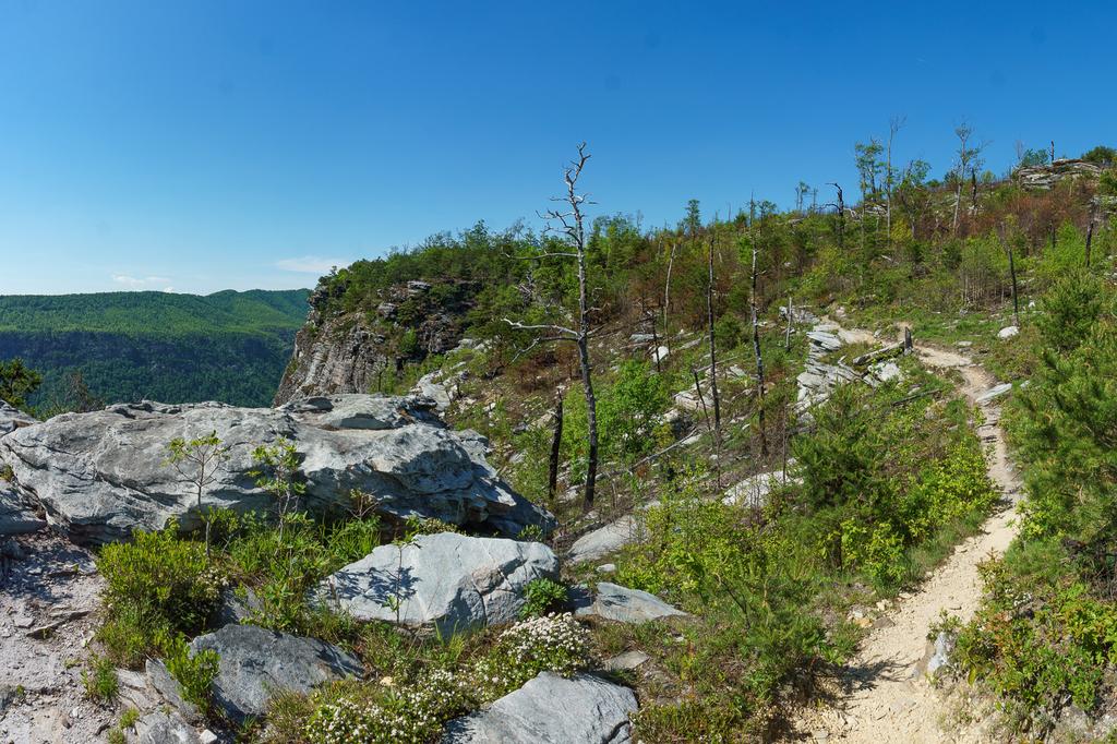
The trail is now heading generally north along just below the rim of the gorge, which at this point consists of pretty much just cliffs, but there is plenty of room for the trail to find purchase, limiting any exposure to the normal kind you find on many trails (stay on the path and you'll be fine). Just ahead you will cross a cleft where water gathers and trickles across the trail from a spring, called "gully pipe".
This water then drops precipitously down into said gully going down into the gorge at a point where you have to step across onto a narrow-ish ledge. I wouldn't go so far as to label it "dangerous", but this one stretch of trail warrants a little bit of caution, especially if you have managed to convince kids (or bribed them with snacks, like I do!) to hike up here with you.
Past the gully pipe, which is enveloped in a miraculously surviving patch of Hemlock (in that they've survived both the fires and a Hemlock Wooly Adelgid infestation), you'll come out on the summit plateau. The terrain is remarkably flat, and you'll climb only another 50 feet or so over the last just-over-1/2 mile of trail. The areas of overcooked ground continue more or less unabated although there are probably more patches of surviving trees on top of the mountain than there are down on its nose.
In this fire-adapted landscape, you may spot some native plants - including some threatened or endangered species - which are now thriving in the open sunshine. Shortoff Mountain has experienced natural wildfires about once every decade, historically, meaning it is a haven for fire-adapted or even fire-dependent native species. Table Mountain Pine (Pinus pungens) regenerates after fires open its serotinous cones, allowing the seeds to spread onto the bare soil. Other herbaceous species, such as the endangered mountain golden heather (Hudsonia montana) grow prolifically in the area after a fire, and native grasses such as Little Bluestem (Schizachyrium scoparium) benefit from the clearing effects of periodic fire as well. Other regional species not especially dependent on fire, such as mountain laurel, simply tolerate it and re-sprout prolifically from living rootstock as if nothing happened after one kills back their stems. Look for these and many more as you pass through the landscape.
You'll pass a fantastic cliff-top, gorge-rim campsite on the left (close enough to gully pipe to use that as the water source). Note: thinking about camping here, or anywhere in Linville Gorge Wilderness? You'll need a camping permit from May 1 through October 31. Contact Pisgah National Forest's Grandfather Ranger District office for details (828-652-4841).
Beyond the campsite, the trail turns right, even heading south a bit, as it makes the final gentle ascent to the southern high point of Shortoff. It's unremarkable and you probably won't even notice it. Just keep going.
By the time you start heading ever so slightly downhill, you'll enter a patch of taller trees. Start looking on the left for the anomalous natural pond which resides way up here about 0.4 mi past the campsite. Not only are natural ponds almost non-existent in the southern Appalachians (all bodies of water you'll see are man-made reservoirs except this and maybe one or two more), it's remarkable that it can be found way up here on this flat-topped mountain. It just seems so out of place, and that's part of what gives it charm. The water is very shallow, and much of it is filled with grass and shrubs. But about 5500 sq ft of open water can be found when there's not a drought, and it stays filled most of the time. It is absolutely teeming with life.

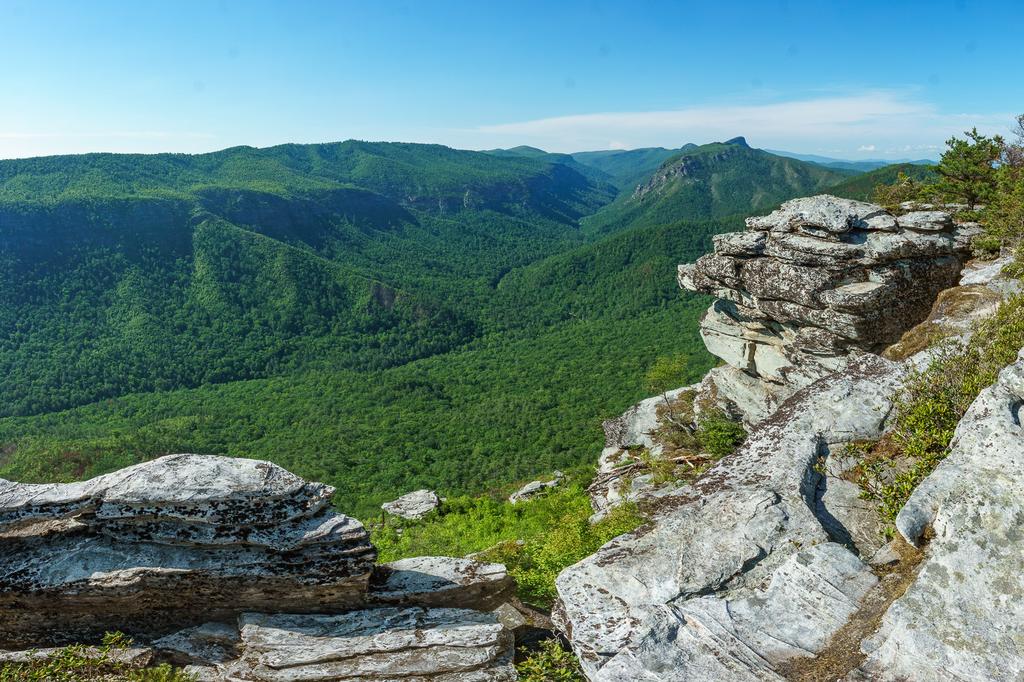
Continue on the Mountains to Sea Trail about 0.1 mi past the pond to a side trail on the left. This leads about 250 ft to another cliff-top view facing northwest, across the river to Linville Mountain and up the gorge to prominent peaks on the east rim including Table Rock and Hawkbill Mountain. This is widely considered to be one of the best views of the Gorge, an assessment with which I strongly agree. Again, use caution - there is plenty of room away from the cliff edge to enjoy the view!
This overlook marks the end of this hike as described, although the Mountains to Sea Trail does continue north, making much longer (up to multi-day) hikes possible. For our purposes, you'll want to follow the path you came on back to the parking area: return to the Mountains to Sea trail, turn right, go back past the pond, and descend Shortoff Mountain, making sure to keep left at the Mountains to Sea Trail/Shortoff Mountain trail junction, and left again at the old road, to finish the hike.

This site is part of the
WNCOutdoors.info network
Western North Carolina
Hiking | Mountain Biking | Waterfalls
Advertising Information | Contact Us
©1996-2025 CC-BY-SA | Privacy Policy