Snowball
At A Glance
TODO: #32 Boilerplate

2.75 mi round-trip
Difficulty Rating: 4.94 ![]()
Climb: Hilly ![]()
Tread Condition: Moderately Rough ![]()
Highest Elevation: 5375 ft
Climb Total: 965 ft
Configuration: Out-and-back
Starting Point: Beetree Gap on the road to Craggy Gardens Picnic Area
Begin the hike by taking the signposted Mountains to Sea Trail (MST) leading west from Beetree Gap (away from the picnic area). The trail begins with a few steps and a short climb, but levels out as it passes by a clearing on the left which brims with wildflowers during the growing season. The little clearing is beautiful, and worth a stop - maybe on the way back so you aren't tempted to just skip the hike and lounge in the meadow!
The clearing has a couple of boulders and rock outcrops in it that mark the spine of this ridge as it curves gently northwest to become the summit of Snowball Mountain. The trail levels out at the clearing and enters a forest filled with hawthorn trees, with a few Red Spruce appearing on the right.
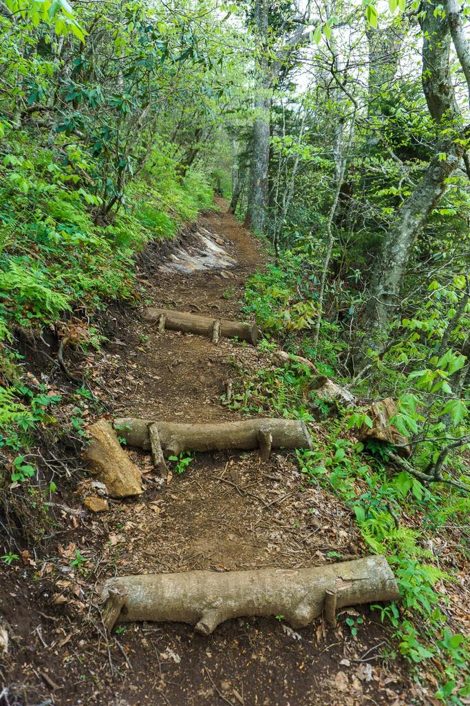
0.1 mi from Beetree Gap, the trail splits. The yellow-blazed Snowball trail goes straight ahead, while the Mountains to Sea Trail goes to the left. Take the Snowball trail, which starts a short climb along the nose of the ridge but again levels out as it swings off the right side of the ridge. It enters a beautiful, open forest of mostly yellow birch trees, and then encounters a set of steps. It's here where the steeper climb to the summit of Snowball Moutain begins in earnest.
The climb is but eased somewhat by a two sets of switchbacks along the way. The first pair of switchbacks is encountered about 0.15 mi past the MST split. After the right-hand turn, a side path leads to the left up to a small rock outcrop on the ridge, which provides a semi-clear view to the south. It's worth checking out, but it's only a small preview of what's to come, so don't linger too long!
The trail gains the ridge beyond this preview overlook, but slips again off the north side after entering an area with more Red Spruce trees. The trail generally sticks to the north side of the ridge to avoid private property on the south side, so be sure to stay on the path. The second pair of switchbacks is reached about 0.4 mi from the MST, and after the right-hand turn you'll be walking along the ridgeline once again.
Look for the USGS survey marker on the right side of the trail just shy of the summit, about 0.6 mi from the MST. The trail passes just to the north of the actual high point elevation of about 5375 ft. just beyond the survey marker. It enters an area of nearly all Red Spruce trees, then curves back to the west and begins descending.

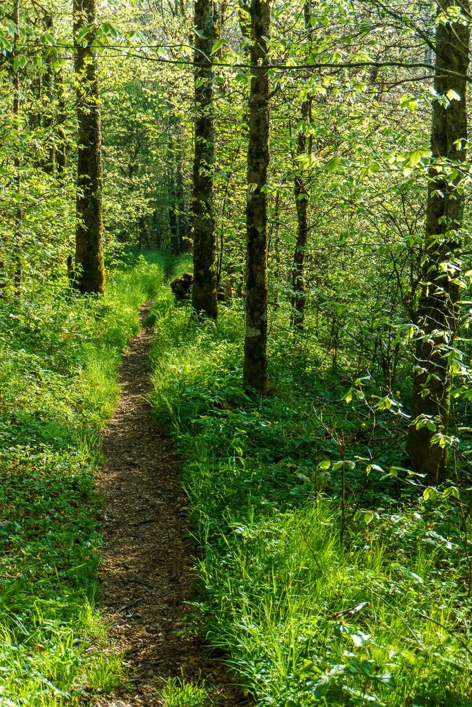
The trail stays on the ridge line for the next 0.2 mi and passes through an area of American Beech with some Red Spruce forest off to the right, with a fabulous ground cover in open areas of grasses and sedges. The trail passes through a level campsite; as it drops off the nose of the ridge, it sweeps south to whip around one more switchback to the north. This area of the forest is one of the last to green up in the spring, and ephemeral wildflowers including several varieties of Trillium carpet the ground here. The trail descends at a good clip the whole way on this stretch.
The trail peels off the face of the mountain and begins a descent down a sharp ridge leading northwest, about 1.0 mi from the MST split at this point. The ridge is narrow, and drops off steeply into the Reems Creek (southwest) and Stoney Fork (northeast) valleys. The vegetation changes noticeably and includes more acid-loving species such as galax, mountain laurel, and rhododendron. The vegetation gives way briefly at one point where the trail levels out and a rock juts up out of the ridge; there is a limited view but again, it's nothing like what's to come at Hawkbill Rock, so keep going!
The trail descends steeply over a set of rock steps past the pseudo-view before bottoming out in a gap with a boulder off to the left, about 1.2 mi past the MST junction.
The trail begins climbing again, now steep in places. It ascends directly up some small rock outcrops, in fact - just shy of being steep enough to require hand-holding, although you may find yourself doing that for stability even if not strictly necessary. You're back into a mountain laurel heath area here. After climbing the first outcrop, a very nice view opens up to the southwest. But don't stop! There's more just ahead.
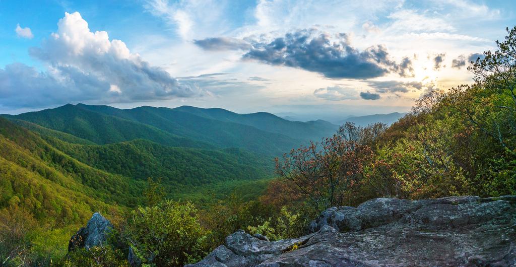
Just a few yards beyond the first outcrop, you'll reach the actual Hawkbill Rock to the left of the trail, where the best view awaits, about 1.3 mi from the MST. Stunted, gnarly trees grow all around the rock, a testament to the harsh winds that can affect this part of the mountain even when the surrounding slopes are calm. Although you don't get a 360-degree view from any one point, you do get about a 270-degree view, from northeast around to west, from the various viewpoints. Use caution; the rock protrudes high above the trees and slopes drop off sharply to the valley below!
The trail does continue beyond Hawkbill Rock, eventually ending up at Little Snowball Mountain and the old fire tower foundation up there, so you could lengthen the hike at least 4 more miles (round-trip) by going that way. Although interesting from a historical perspective, Little Snowball's view is largely overgrown and the rest of the trail isn't nearly as nice, in my opinion, as the part out to Hawkbill Rock. If you're looking for more mileage, a nicer alternative would be to turn right back at the MST junction and go down to Potato Field Gap, then up to Lane Pinnacle. Or, continue across the picnic area road on the MST when you get back to your car, and hike up past the picnic area to Craggy Gardens.
So this hike officially ends here. Return to your vehicle on the same path after soaking up the views.
Remember, it's a stiff climb back up to the summit of Snowball Mountain so be sure to allow yourself enough time on the return trip!

This site is part of the
WNCOutdoors.info network
Western North Carolina
Hiking | Mountain Biking | Waterfalls
Advertising Information | Contact Us
©1996-2025 CC-BY-SA | Privacy Policy