Craggy Gardens
At A Glance
TODO: #32 Boilerplate

1.4 mi round-trip
Difficulty Rating: 1.89 ![]()
Climb: Climbs Moderately ![]()
Tread Condition: Some Obstacles ![]()
Climb Total: 200 ft
Configuration: Out-and-back
Starting Point: Craggy Gardens Visitor Center
Trails Used: TODO dynamic list Craggy Gardens, Mountains to Sea
Begin the hike at the far south side of the visitor center parking area (to the left as you face the building). The trail starts at the end of the rock wall, and it has a sign.

This is a short, self-guiding nature trail that travels uphill through a forest of stunted, twisted high-elevation mountain ash, birch, and beech trees, and finally through a heath bald. The sign at the beginning states that it is a 20 minute hike out to the shelter and back, which is roughly correct if you hustle, but you'll want to take more time than that and explore all that is to be found in the spectacular environment around you.
Shortly after leaving the parking area, you'll reach a signed intersection. The Mountains to Sea trail comes in from straight ahead and goes right, downhill. The downhill route is also the way to Douglas Falls on the mountain far below, so you'll see a sign for it as well. Keep straight, uphill. The path you're now on is shared by the Craggy Gardens trail and the Mountains to Sea Trail. The latter stretches all the way from the Blue Ridge to the Outer Banks! The section you're hiking is less than a mile long.
Along the way, signs point out elements of the high-elevation environment and identify some of the plants and animals you may encounter. You'll pass a small spring along the way and then into tunnels of tall, twisted Rhododendrons. You'll pop out of the rhododendrons at the historic trail shelter, built from Chestnut logs - a species long since relegated to stubby sprouts from dying root systems, due to an introduced blight. Although it is nearly a century old, it's still sturdy, and it will still more or less keep you dry if a rain shower should appear while you're in the area. (It won't keep you warm though - be prepared for fluctuating and cold temperatures up here).
From the shelter, you can go uphill on a side path and explore the "gardens". This area is known as Craggy Flats. You'll find grassy, open meadows interspersed by patches of blueberry, blackberry, and rhododendron bushes. There are some stunted oak trees which are gradually encroaching on the area as the years go by. Kids will love finding secret hiding places under the Rhododendrons.

There are also great views from up here, especially of Craggy Pinnacle to your north. A couple of pleasant little paths wind through the meadows, eventually reaching a nice overlook if you go all the way to the top. In late 2017, the Blue Ridge Parkway Foundation and partners completed a trail maintenance project in the area, meaning it's in even better shape than years past.
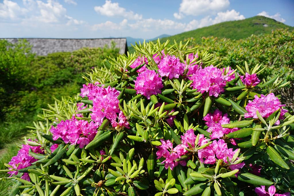
And speaking of the Rhododendrons, they put on a spectacular display of purple flowers in late June, along with the blooms of mountain laurel which come soon after and the fruit of the Blueberry bushes in later summer. This is an excellent family hike with spectacular views and plenty to explore and learn along the way!
Other Hiking Options in the Gardens Area
The Craggy Gardens trail continues through the shelter and down the other side of the summit. Co-signed as the Mountains to Sea Trail, you will reach the Craggy Gardens picnic area after a short descent on a moderately steep trail. The trees are a bit taller on that stretch trail and include birch, beech, and oak. There is a gazebo just off the trail about halfway down, and as of late 2017 the trees have been cleared back to open up a view. It's a nice spot to relax.
If you are picnicking at the picnic area, start the hike from there instead, going up to the gardens for a slightly better workout than you get coming from the visitor center. It involves a climb of about 450 ft over the same distance as it is starting at the visitor center. If you are able to have someone drive a vehicle up the Parkway as a shuttle, you could start at the Visitor Center and end down at the Picnic Area for an easy hike; for a more moderate workout, start at the Picnic Area and end at the Visitor Center.
Douglas Falls is an 8-mile round-trip, steep, difficult trek into a wilderness-like area ending at the 70-foot free-falling waterfall with the same name. A much easier, 1/2 mile hike to the falls starts after a 16 mile drive from the visitor center down into the valley and halfway back up.

This site is part of the
WNCOutdoors.info network
Western North Carolina
Hiking | Mountain Biking | Waterfalls
Advertising Information | Contact Us
©1996-2025 CC-BY-SA | Privacy Policy