Crabtree Falls
At A Glance
TODO: #32 Boilerplate

3 mi round-trip
Difficulty Rating: 4.14 ![]()
Climb: Hilly ![]()
Tread Condition: Some Obstacles ![]()
Highest Elevation: 3760 ft
Climb Total: 480 ft
Configuration: Loop
Starting Point: Signed parking area at Crabtree Meadows Campground, milepost 339.5
Trails Used: TODO dynamic list Crabtree Falls Loop

Start the hike on the paved trail behind the parking area. It winds down the short paved section, goes past an old amphitheater for the campground, and through a meadow filled with wildflowers along an old woods road. In just under 0.2 mi there is a fork; bear right to stay on the path to the falls. (This is signed). You'll come out on the campground road after about 450 feet. Ahead of you and to the right (across the campground road) is the old parking area. And at the back of that parking area is the old trailhead and a trail sign.
This trail sign lists the hike as a 2 mile strenuous loop, but the map more accurately depicts the situation. It is 0.6 miles to the falls and 1.9 miles from the falls back to the campground, so it's actually a 2.5 mile hike from this spot. When you add in the 1/2 mile out-and-back from the visitor center, that brings the grand total for the hike to 3 miles. But the only truly "strenuous" section is a short one on either side of the falls, where the trail climbs steeply up and down the ridge. Aside from those, it levels out and gets relatively easy again. "Strenuous" is used in context with those who might typically use this Park Service campground, but for users of this web site comparing trails across Western NC, "moderate" is a more accurate description of the difficulty as a whole.
Take the trail behind the sign board. You will immediately walk beneath a thicket of Rosebay rhododendron. This becomes a beautiful tunnel of white flower petals in July, and in some seasons I've seem them last into early August. You'll quickly reach the intersection with the other side of the loop; you can go either way but for this hike let's get to the good stuff: turn right to begin the descent to the falls.
The trail is wide, smooth, and graveled at first, and takes you through a mixed hardwood forest, just at the lower fringe of the Northern Hardwood tree species zone. All along the loop, you will notice some very large trees. Excellent examples of oaks, maples, tuliptrees, and hemlocks show that this forest is maturing and should one day be considered old-growth due to its Federal protection from logging and development as part of the Blue Ridge Parkway.
The trail goes downhill through a shallow, high cove with a mostly dry stream bed at the bottom. As you reach a point where the stream becomes much steeper, it spits the trail out onto the mountainside to the right, which it begins to traverse. Here, the trail surface becomes considerably rougher. It's about here where you can start to hear the falls as well.
The trail switches back and forth several times before reaching the base of the falls. You will encounter some rocky sections, sets of rock steps, roots, and wet areas. There is plenty to look at and enjoy along the trail - you could make it last the whole day if you had to, and it would be well worth the walk!
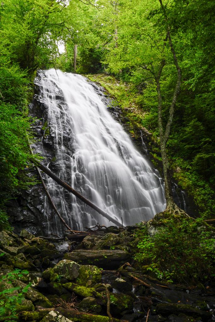
At the base of the 70 ft falls, the trail crosses a nice wooden bridge with a viewing bench built right in to it. A lone birch tree, present in nearly everyone's wide-angle shot of the falls, grows in the middle of the stream on an "island" below the cascading water. The falls is especially photogenic as the water spreads into a wide veil on the way down. Good vantage points for photography can be found from the left and right banks, and even from directly in front.
Take care when leaving the trail - boulders and rocks can be very slippery. On a hot day, there is a nice wading pool at the base - which requires a tricky climb over some boulders to get to - but the constant mist will keep you quite cool. There is absolutely no way to the top of the falls.
If you are continuing the loop, the hardest part of the hike is just past the falls. (If you are not, be prepared for a fairly steep climb back out - just not as bad as on the other side of the loop.) You'll climb 200 ft or so in the next 1/4 mile. The trail climbs steeply and switches back many times as it ascends the ridge. It seems to "bounce" from large tree to large tree, with one tree - here an oak, there a poplar - anchoring the tip of each switchback.
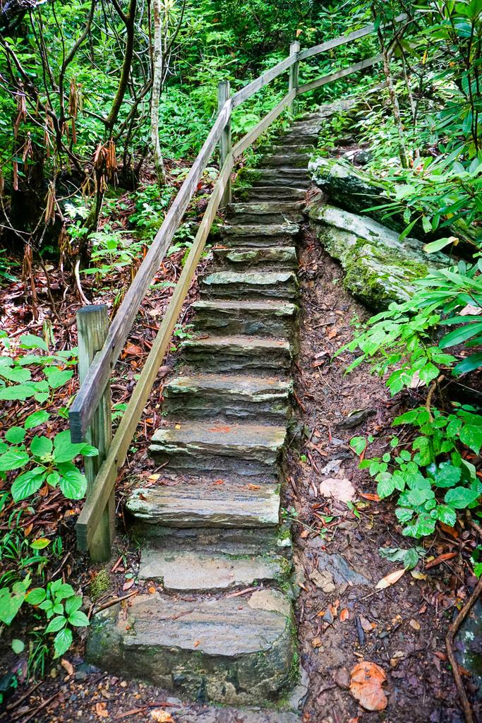
Nearing the top, the Park Service has provided a nice resting bench, which you might actually want to use - because the next section goes directly up a long set of stairs! You'll then achieve the nose of the ridge, follow it for just a little while, and then begin traversing the mountainside where some stone retaining walls have been built to hold up the trail. The steepness lessens a little here.

You'll then reach a rocky outcrop that seems to be part of the same geologic feature that forms the falls. This cool section of the trail sort of clings to the side of this rock cliff, but it's wide and safe, if you just stay on the path. A handrail is provided when the trail climbs some more steps around this nose of rock. At the top of the steps, and to to the left, is an opening in the trees with a decent view (especially in the winter).
Since most people will hear falling water and be curious: yes, there is also a very faint, mostly obscured view of the falls below. But to see it, you have to get too close to the edge and lean out. Trust me, this crappy view is not worth the risk. Stay on the main trail. A bench is provided here, and it is much more pleasant than being on the receiving end of a search and rescue mission.
This is the top of the really steep climb, and from here the trail widens and is mostly smooth. It actually descends slightly to reach the creek, and crosses a small tributary on a wooden bridge. There are some huge hemlocks growing in this area, and the other vegetation is typical of streamside areas in the mountains. Glimmering pools at the base of small rapids and cascades contain mountain trout - keep an eye out to see them darting in and out of the sunlit areas.
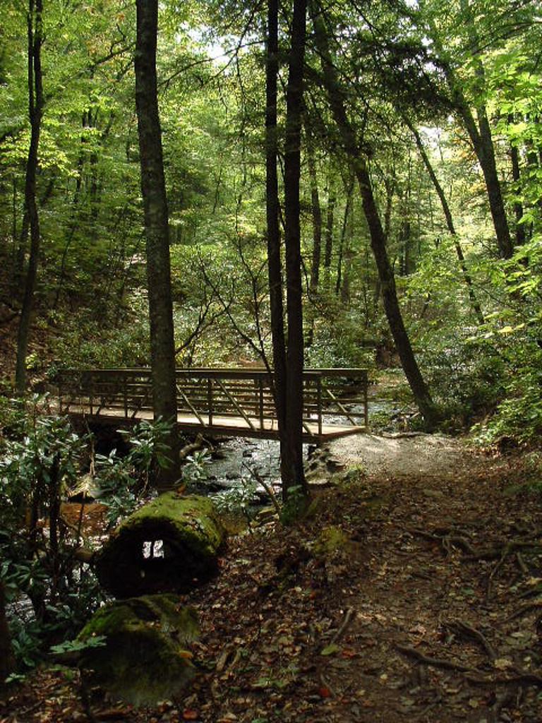
You'll cross the main stream on an impressive new bridge - a great improvement over the bouncy log that existed here before. The structural members of the bridge are fiberglass-infused polyester resin. This corrosion-resistant, lightweight, easy-to-assemble structure represents a new design being used in trail bridges. I hope it catches on, because the bridge is convenient to hikers, safe, and its light green color is unobtrusive in this forest setting. It should also be long-lasting; it was still in great shape at least 12 years after its installation.
Beyond the bridge, the trail first follows, and then gradually pulls away from, the creek. It will round a small, very low ridge, then descend just slightly again and begin following a small tributary upstream.
Some northern hardwoods grow in this area, as well as several large-leafed Fraser magnolias. These trees, also known as Mountain Magnolia, have the largest leaves of any native Southern Appalachian tree, and they can also be recognized by their growth habit: lots of saplings shooting up from the roots of the main trunk, or a cluster of large, main trunks on older trees. You'll also pass beneath maples and oaks, as well as birches and beeches.

You'll cross the small tributary on a log bridge. I've always found this section of the forest to be exceptionally quiet and relaxing. Except once, while crossing this bridge on a hike with my father, when we stopped on the bridge to take a drink and - by pure coincidence - listened as an enormous tree come crashing to the ground, somewhere in the distance. It was a clear, still fall day making the sound seem like it came out of nowhere - and a rather eerie experience!
Just past the crossing, you'll head a little more steeply uphill until you reach the highest seep of the tributary and enter drier woods. The the trail climbs moderately up to another signed intersection. Continuing straight takes you to the back loop of the campground, and it's just a short walk along the campground roads back to your vehicle from there - so you could knock off about .3 mile from the hike by going that way.
The loop trail officially goes left, which is the way measured for this hike. It travels through more mixed hardwood forests on a nicely graded path to the close of the loop.
Turn right at this last intersection to head back up to the old parking area. Continue straight across the campground road to the trail leading back to the visitor center, your vehicle, and to the completion of the hike.

This site is part of the
WNCOutdoors.info network
Western North Carolina
Hiking | Mountain Biking | Waterfalls
Advertising Information | Contact Us
©1996-2025 CC-BY-SA | Privacy Policy