Mount Mitchell
At A Glance
TODO: #32 Boilerplate

11.4 mi round-trip
Difficulty Rating: 19.9 ![]()
Climb: Climbs Steeply ![]()
Tread Condition: Moderately Rough ![]()
Highest Elevation: 6684 ft
Climb Total: 3689 ft
Configuration: Out-and-back
Starting Point: Black Mountain Campground (or optionally Mount Mitchell State Park summit parking area)
Trails Used: TODO dynamic list Mount Mitchell, Higgins Bald (optional)
Mount Mitchell is the highest peak east of the Mississippi river at 6,684' in elevation. While there are much easier ways to reach the top, part of the appeal of this hike is the experience of "summiting" this superior peak. This hike qualifies as an accepted route for the South Beyond 6000 Program by the Carolina Mountain Club, which recognizes members who climb all 40 peaks above 6000' in the Southern Appalachians.
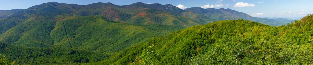
This hike has developed somewhat of a legend around its difficulty, partly because Mt. Mitchell is the highest peak in the region. Although that's the case, the campground sits at a respectable elevation of 3000 ft. itself, meaning the difference from the base to top isn't as high as it could be. The trail does have one of the highest elevation changes of any single-name trail in the region at 3600 ft., and it's got its fair share of roots, rocks, and rough sections. But there are harder trails (or hikes combining multiple trails) in the region as well.
Ultimately, how difficult you find it to hike, and how long it will take you, will depend greatly on your fitness and level of experience (just read the comments on this page!), but to be safe, it should be considered quite difficult unless you're certain that you're up to it.
It's very doable as a day hike, although some people choose to do the trail over 2 days, spending the night near the top. Allow a full day with plenty of time to spare if it's your first trip.
You could also start at the top and hike down, but if you don't have a vehicle shuttle you'll have to hike back up anyway. One good option to lessen the strain, but still make for quite an achievement, would be to leave a vehicle shuttle at the summit parking area and hike up, then avoid the impact on the knees by driving back down.
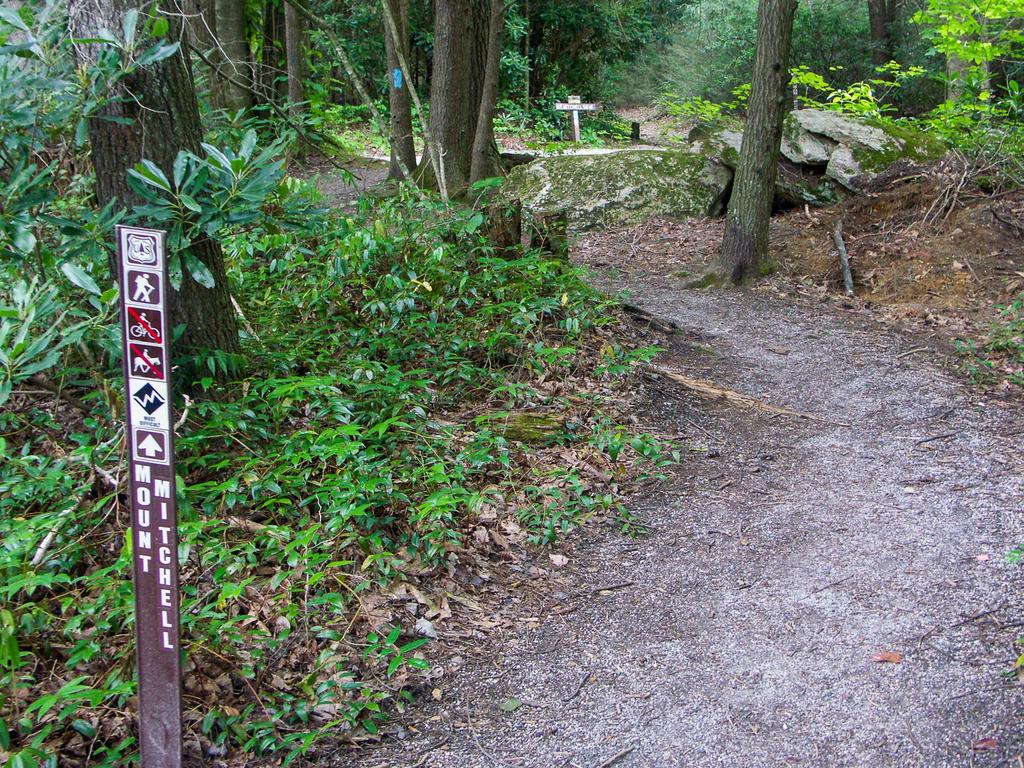
This hike's description assumes you're starting at the bottom going up. Although several other named trails share the path you'll be taking, you can just follow the blue-blazed Mount Mitchell trail the entire route.
Begin the hike by crossing the bridge leading into the campground. Bear left at the first intersection onto a campground loop road; from here, follow the signs for the Mount Mitchell trail all the way to the top. The easy Briar Bottom/Mount Mitchell trail angles left off the campground loop road and winds up by the S. Toe River. Follow it for a few yards to the intersection on the right with the Mount Mitchell trail, going back across the gravel road.
Now on the Mt. Mitchell trail proper, the climbing immediately begins in earnest. At this elevation, the forest is mostly cove hardwoods with a few hemlocks thrown in for good measure, though they are dead or dying. You will ascend through a small cove, whose stream is gradually eating its way into Long Arm Ridge. Toward the back of the cove you'll bear right through the first of many switchbacks encountered along the way. The trail at the start here heads generally north, though at any given moment you my be facing any of the cardinal directions due to the way it switches back upon itself. The trail climbs up the side of Long Arm Ridge.
Some very large trees grow in the forest here, and as you gain elevation on the ridgeline you enter a mixed oak hardwood forest. A few small Red Spruce trees grow here, although they're out-of-place at this low of an elevation and will likely be shaded out before reaching maturity. The footing on this section of the trail is mostly good, with only a few rocky or rooty sections.
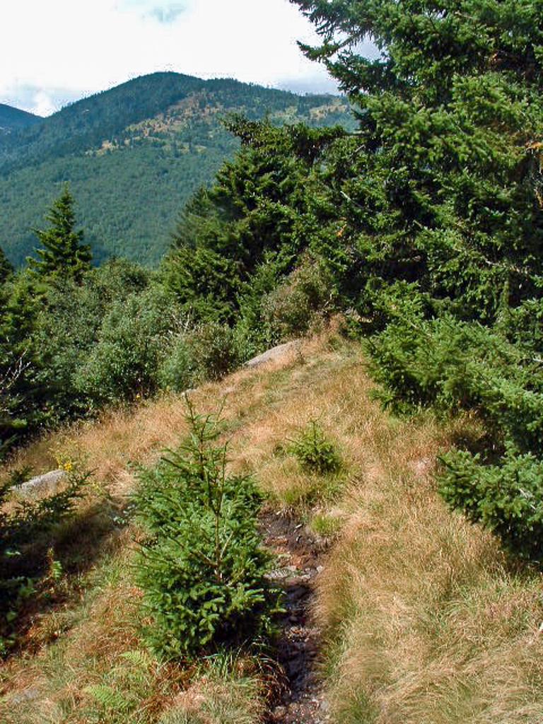
After achieving the top of Long Arm Ridge, the trail turns west and ascends its spine, swinging back and forth across it in places. You'll break past the 4000 ft. elevation mark on this section of trail. The trees along the ridgeline - predominantly oaks and maples - are now shorter. They're stunted compared to the ones lower down by this area's exposure; the shallow, rocky soil; and lack of water as these steep slopes drain quickly. Some rougher sections of trail start to appear, although it's still the climb more than the surface that makes it challenging.
You'll reach a trail junction shortly and you can take either fork. Both trails come back together eventually; the left fork is called the Higgins Bald trail while straight ahead is the Mount Mitchell trail. You could also save the Higgins Bald trail and take it on the way back down, or skip it altogether.
East of the junction, the ridge sort of melts into a high, steep slope of "Little Mountain", which you'll traverse. The mountain won't seem very little as you climb it, though!
The Higgins Bald trail extends the hike by about 1/4 mile but takes you through the (formerly) scenic, eponymous heath bald. Climbing rapidly, the trail generally passes into the northern hardwood forest zone in this area. You'll cross the upper reaches of Setrock Creek, an easy rock-hop with as little flow as there is this high up the mountain. There are some cascades downhill from the trail, but they're not really worth expending effort to try and see.
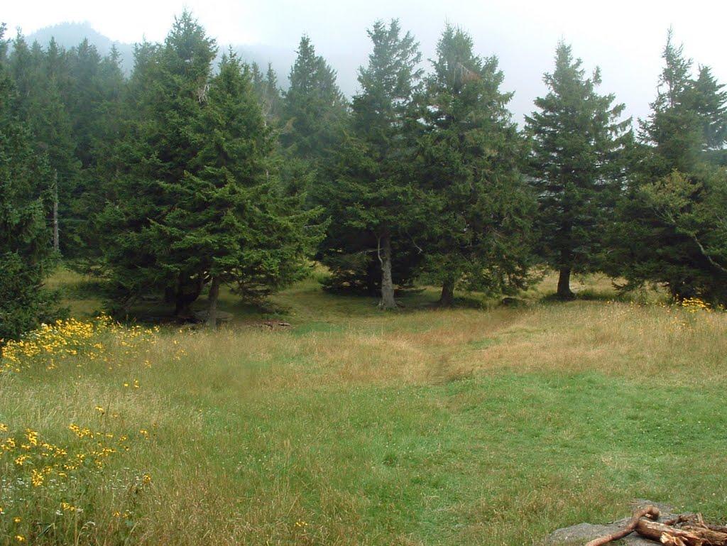
Then you enter Higgins Bald itself. Roughly halfway to the top, this forest opening - which sits on a gentler slope above Flynn Ridge - lets you look down and see how far up you've come, and also look up to see how far you have left to go! (At least it used to have these views - it's apparently become too overgrown to see much in recent years, unfortunately. I'm holding out hope for a wintertime view remaining). Commissary Ridge looms above, which you'll soon begin to climb, and which culminates at the summit of Mount Mitchell itself. Lots of dead hemlocks stand in the forest encircling Higgins Bald.
You'll re-enter the forest on the other side of Higgins Bald, and then join back with the Mount Mitchell trail after a short distance; bear left (if you took Higgins Bald; continue straight if not).
The trail curves to a more northwesterly direction in general, just after crossing the 5000 ft. contour. You're now well into the spruce-fir forest zone. You'll walk through a spectacular virgin forest of tall, straight Red Spruce. Seeing them growing here gives you a glimpse of what forests all over the Black Mountain range used to look like, and a glimpse at why the forest was so valuable to loggers. The straight, resilient spruce wood was seemingly plentiful, so these trees were prize timber. Luckly, some patches such as this one survived, and other areas of spruce are starting to re-grow.
Sections of the trail in this area are very rocky and steep, and require some hand-holding to traverse. As you continue to climb through a series of switchbacks - and some of the steepest sections of trail on the hike - you'll cross under the power line right-of-way a few times, where there are some limited views.
Then you'll pop out of the forest onto the old railroad grade that encircles much of Mount Mitchell and provided a way for the loggers to get the fruits of their labor off the mountain. Turn left at this intersection, in a wet area (during periods of rain).
The path for the next few yards is shared with the Buncombe Horse Range Trail as it follows the railroad grade on a nearly level course, just shy of 5800 ft. elevation. You'll need to turn right off the railroad grade to stay on the Mt. Mitchell trail and begin the final 900 ft. climb up Commissary Ridge to the summit. The trail is well-signed and blazed so it shouldn't be hard to follow, unless perhaps if it's very foggy.
Just beyond that junction, the old railroad grade swings around toward the south side of the ridge. A great campsite is on the left at Commissary Hill in case you're looking for a place to spend the night. It is on Pisgah National Forest property, so backcountry and dispersed camping is allowed. (It is not allowed higher up, on NC State Park property, outside of the designated campground.)
This area receives much more precipitation than down at the Toe River, so the trail is a lot wetter up here in general, and everything is draped in lush, green moss. However, it can become bone dry during periods of drought since these steep, rocky slopes drain so quickly. Don't count on water beyond approximately the elevation of the railroad grade during dry spells.
The patch of forest as you start the climb up from the railroad grade on the Mt. Mitchell trail is mostly composed of imported Norway spruces. Native Red Spruce and Fraser Fir soon take back over the species list. You climb above the 6000 ft. contour not far beyond the second switchback past the railroad grade. The ridge in this area is pretty rugged, and you'll pass one nice, deep fracture cave on the way up through the switchbacks. Open glades with spruces all around give the area an alpine feeling.
You'll climb up onto the crest of the ridge after a relatively rough and eroded section of trail, and there, the forest becomes composed of almost pure Fraser Fir and some mountain ash. The trees get shorter near the top, attesting to their young age. These stands of Fir are ravaged by high winds, poor soil, and - within the last 50 years or so - a Balsam Wooly Adelgid insect infestation. 90% of the mature Firs are killed by the adelgids, which are related to the Hemlock Wooly Adelgids wiping out the hemlocks further down the mountain.
Luckily for the firs - and unlike the hemlocks - they are able to survive long enough to reproduce before the adelgids kill them, and large areas of lush, young firs still grow up here. Their ultimate survival remains to be seen in the face of pollution and climate change.
Once you reach a flatter section of trail with puncheon (sticks) laid across it to keep your feet out of the mud, you know you're getting close to the summit! You are on Mount Mitchell State park property now, having been on the National forest most of the route. (You may notice the sign welcoming you to the state park, but I didn't last time I hiked this.) Next, you'll reach the intersection with the Balsam Nature Trail, which leaves to the right. Continue straight ahead.
From that junction, the trail sees a good bit more use and you may share it with more adventurous tourists and their kids. You'll pass by an enormous, free-standing boulder on your right and a neat cave on the left. You never really get a view of the summit until you're right below it; at this point you're nearly done with the hike as you come out near a park building and a paved path. Turn left on the paved path and climb a few more feet to the summit.
So yes - I must admit that the last few yards of this hike are vastly different from the rest of it, since you've entered a developed tourist area. In fact, some people describe it as...well, a bit jarring! Or an underwhelming end to such a promising hike. That's understandable, since you've hiked through nearly 6 miles of wild lands up the East's highest mountain, only to now find yourself elbowing your way through hordes of tourists, who will be huffing and puffing their way slowly up the paved summit path. (Folks eating cheeseburgers from the concession stand will be sitting on resting benches found beside the path, or hitching a ride up in a golf cart from a park ranger).
Ok, that might be a bit of an exaggeration (they don't sell cheeseburgers at the concession stand)...but if you feel like a crowded summit might be a let down, just don't do this hike on a summer or early fall weekend. Try it on a "bad" weather day during the week (with proper gear, of course), or better yet when the Blue Ridge Parkway and State Park are closed. The trail remains accessible, yet you'll be all alone.
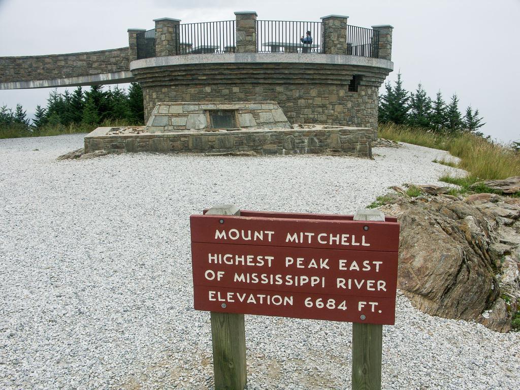
Tourists or none, you'll soon forget all about it as you wind your way up around the circular stone viewing platform that now sits just proud of the summit rocks. The views from up there are wonderful - and you'll want to take a well-earned rest to enjoy it before heading back down.
The deck of the platform is as high as you can get, east of the Mississippi. So enjoy your accomplishment, enjoy the view, grab a cheeseburger to eat and get ready - because you're half way done with the hike!
Return to your vehicle on the same trail. It will be a left at the railroad grade, then a right on the Mt. Mitchell trail on the way back as well. Be sure to take the other fork at Higgins Bald to enjoy the most variety on the hike!

This site is part of the
WNCOutdoors.info network
Western North Carolina
Hiking | Mountain Biking | Waterfalls
Advertising Information | Contact Us
©1996-2025 CC-BY-SA | Privacy Policy