Sam Knob
At A Glance
TODO: #32 Boilerplate

2.2 mi round-trip
Difficulty Rating: 3.58 ![]()
Climb: Climbs Moderately ![]()
Tread Condition: Moderately Rough ![]()
Highest Elevation: 6050 ft
Climb Total: 570 ft
Configuration: Out-and-back
Starting Point: Black Balsam Parking Area
Trails Used: TODO dynamic list Connector trail, Sam Knob Summit
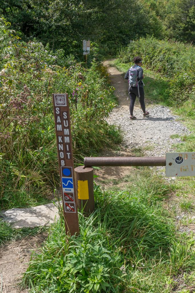
Begin the hike on the trail that follows the old gated road to the right of the pit toilets. It's called the Sam Knob Summit trail and is usually signed. This trail follows an old roadbed, level at first, with a gravel surface.
To the left is a stand of Red Spruce trees which were planted in this area as a reforestation effort in the early 1900's. Similar stands can be found along Black Balsam Road leading to the parking area, along the Flat Laurel Creek trail, and skirting the summit of Black Balsam Knob. In addition to these dense, planted stands, scattered naturally occurring Red Spruce dot the landscape at these elevations.
The trail passes a pretty glade in the spruces on the left that is brimming with wildflowers during the spring. Beyond the glade, the trail travels through a mixed forest, consisting of mostly high-elevation hardwoods such as birch and maple, and other familiar trees such as Mountain Ash, Red Spruce, and Fraser Fir. Blueberry bushes can be found off this stretch of trail as well.
The trail soon begins a curve to the left, and begins to descend. Here you'll get your first glimpse of Sam Knob, the double-topped peak looming in the distance. Don't worry, the climb is not nearly as bad as it looks from this vantage point!
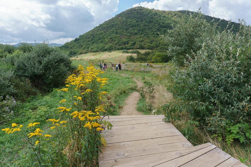
You'll soon begin to descend in earnest. This stretch of trail now has a large boardwalk and staircase structure installed to smooth over the formerly rocky and rooty path, so it is now an easy descent. The vegetation is now mostly shrubs and small trees, and many wildflowers bloom amongst the forest openings.
At the bottom of the steps, the trail enters a large, scenic meadow with Sam Knob directly behind. This meadow is kept clear of trees by mowing.
The trail crosses the meadow, and reaches a T intersection with the Sam Knob trail on the other side. Inexplicably, the Sam Knob Summit trail actually ends here; to the left and right is called the Sam Knob trail. Turn right on the Sam Knob trail to go toward the summit.
Once on the Sam Knob trail, the climb from this meadow to the top is just shy of 400 ft, which is done over a fairly long distance via several switchbacks. This makes for a gradual, easy ascent.
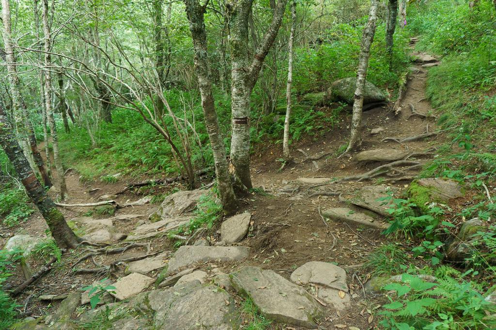
You'll be climbing the south side of Sam Knob in a lush, young forest of mostly northern hardwood trees. There are a few rooty and rocky areas along the trail as it has become more eroded in recent years, so pay attention to your footing. When this trail was first built, it looked like it would shed water well. Unfortunately, due to a lack of ongoing maintenance, it is getting pretty rough in spots (although it's not nearly as much of a lost cause as some other trails in the area - yet).
The trail goes through a few switchbacks, and it will rise up above the taller trees, with some great views - but it's just a glimpse compared to what you will get from the top! Lush vegetation grows near rock outcrops beside the trail, including blueberries, strawberries, sedges and grass, mountain laurel, Carolina rhododendron, and countless wildflowers including bluets.
At one point you will ascend a set of wooden steps up a particularly steep and rough spot. Then, the trail will pass beneath some large rock outcrops, which lie just below the summit. There is a great view on the left. The terrain levels out as the trail wraps around to the west side of the summit. You'll reach a grassy, shrubby saddle between the two high knobs, and a large outcropping of snow white quartz juts from a grassy meadow beside the trail. Just beyond this outcrop is where the trail splits.
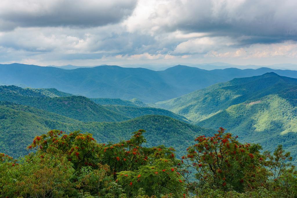
Turn right and head to the top of the south summit, the lower of the two high points on Sam Knob. This grassy spot is a good place to hang out and enjoy the views of the Shining Rock Ledge to your left, Black Balsam Mountain with the big meadow you walked through in front, Little Sam Knob to the right and Silvermine Bald on the horizon. In the valley below, to your right, is NC 215 as it winds its way up the valley to the Blue Ridge Parkway. Jutting up over the ridgeline you can make out Devils Courthouse beside the Blue Ridge Parkway. And behind you are views of the other summit of Sam Knob.
Shortcode: Gallery Here
Turn around and head to the top of the north summit, just a couple hundred feet away. This is the highest point on Sam Knob, elevation 6045 ft. The view from here is of Fork Mountain to your right, Fork Ridge (yes!) to your left, and the West Fork Pigeon River in between.
Why is this mountaintop devoid of the tall trees that are so common in this area? There is no true timberline in these mountains, above which trees can't grow like out West in the Rockies. Rather, these are locations called "balds" where only grasses or low shrubs grow. Like Black Balsam Knob across the field, and many other mountains in the area, Sam Knob is a "bald". Here the trees have a hard time re-establishing themselves once cleared by fire or man, due to soil conditions, weather, or grazing by animals. The exact cause of the balds, and their perpetuation, is a subject of study for scientists in the area.
On the summit of Sam Knob, mostly low shrubs grow, but there are some trees advancing up the slopes. Still, the view from the top is outstanding. Visit during late June, when the Rhododendrons are blooming, or in September when the Mountain Ash berries turn red, and you won't be disappointed with the foreground either.
When you're finished enjoying the view, return to your vehicle on the same trail. Alternative return route: the Sam Knob trail descends to reach the Flat Laurel Creek trail if you continue straight instead of turning left at the big meadow; a left on Flat Laurel Creek trail would then bring you back to the parking lot. That route would give you a longer, slightly more difficult yet more scenic loop hike on the way back, and that's the route for the Flat Laurel Creek Best Hike on this site. Combine them to make an epic Sam Knob/Flat Laurel Creek outing!)

This site is part of the
WNCOutdoors.info network
Western North Carolina
Hiking | Mountain Biking | Waterfalls
Advertising Information | Contact Us
©1996-2025 CC-BY-SA | Privacy Policy